Heard about flickervision? A site showing realtime geotagged Flickr pictures on a Google world map. Neat site, the pictures pop-ups nice and smooth. Should be really interesting if you could select pictures from your own album / tags.
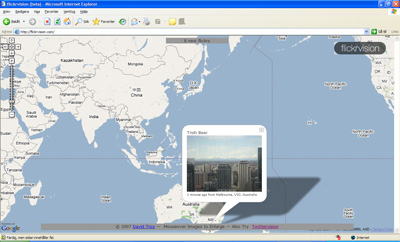
Flickervision – sneak peek around the globe
Posted May 17, 2007 by LarsCategories: flickervision, Flickr, Geocode
Good pipes from yahoo
Posted May 14, 2007 by LarsCategories: Flickr, Geocode, Google Earth, Images, Yahoo pipes
Well, now the Yahoo pipe seems to work. Use this link to se my geotagged pictures from FLICKR in Google Maps. Amazing!
http://pipes.yahoo.com/pipes/pipe.run?_id=Uo7ZaIYA3BGxYDH8X0sBXw&_render=kml&_run=1&nsid=76099759@N00&tags=
(Just change the nsid parameter in the above link, to show your own flickr photos)
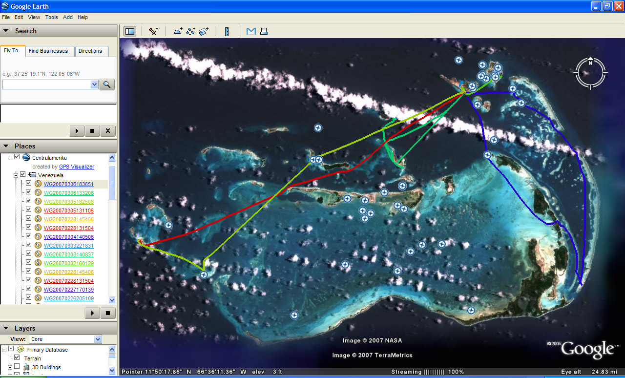
In combination with the logs from my trip you get a really cool photo album. Take a look at this screendump from the Andes (Merida, Venezuela) and see for yourself. The red line is my GPS log (I went by telerifa to 5000meter and back) and the yellow pins are photos taken during the tripp, auto-mapped using Sony GPS Image Tracker. Neat!

Showing a true pipeshow in Google earth.
Yahoo Pipes – Export FLICKR pix to google earth
Posted May 13, 2007 by LarsCategories: Flickr, FlickrFly, Yahoo pipes

Found an interesting discussion concerning geocoding on Flickr today. There was “pipe” developed to export gecoded photos in Flickr directly to google earth. Have been looking for something like this, since I think Google Earth is a excellent program to use if you wan’t to make a cool presentation of your travel photos…However the links to the pipe didn’t export any pictures when I tried it today!?
Here is a link to the pipe, if you have an FLICKR ID, you can try if on your own.
http://pipes.yahoo.com/pipes/pipe.info?_id=Uo7ZaIYA3BGxYDH8X0sBXw
Flickrfly is cool, but can only server one picture at a time. I will continue to examine the pipe and see how to get it started to serve full albums to Google Earth.
GPS Fixed
Posted May 13, 2007 by LarsCategories: Sony Center, Uncategorized
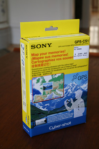 Got my GPS CS1 back. Sony could not fix it the stuck on/off button(?!), so i got a brand new unit instead (for free). Thanx Sony! After a short look at the wrapping and the CS1, no updates seems to be made. In other words, it’s exactlly the same vesion as the broken one. Hopes this one will survive more than 3 months of geocoding.
Soon you will have som brand new geocoded photos and different environements to test the GPS in.
Uploaded GPS-log (KML format)
Posted April 10, 2007 by LarsCategories: Geocode, Google Earth, Gps, gpsvisualizer, Sony GPS-CS1, Uncategorized
 So, finally uploaded the GPS log from my trip. Please note that you have to unzikp the file and open the doc.kml file using google earth.
>> GPS log converted into google earth <<
(file is named centralamerica.zip)
The logfiles are catagoriezed by country and you can see what date is was created by checking the filename (YYYYMMDD). Some days have several logfile, the reason for this could be that I had to turn the GPS of or changed batteries. In some cities, the result is terrible. I Guess that the GPS-satellites were jammed by large buildings (etc in Panama City or Guatemala City) and since I always traveled by taxi, the GPS had trouble following me. The most interesting logs could be found in Xela (Guatemala) and Los Roques (Venezeuala), were you easily could follow my boat-rides between different islands from day to day. To bad that the map details for Los Roques are low, but you could still see what islands i visited.
Problems with my Sony GPS-CS1
Posted March 29, 2007 by LarsCategories: Geocode, Sony Center, Sony GPS-CS1
 Guess what, when I tried to turn on the GPS yesterday, it was impossible to start. Old sand / mud / dust seemed to have jammed the On/Off button (i have stored it in a box for the last two weeks) . The USB connection to my computer still works, but it’s simple impossible to start the damn GPS again.
Contacted Sony Center in my hometown (Malmö), they couldn’t clean it / get it to work and said that I probably had to send it to Sony to fix it. However, they refused to help me further, since I forgot to bring my reciept… Wonder how many GPS-CS1 they actually sold in Malmö…Should really be interesting to talk to them again during the weekend.
So, 8 weeks of intense use in central America was probably to much for the toy. Well spend $150? You decide.
GPS-CS1 summary based on my travel experince
Posted March 24, 2007 by LarsCategories: Geocode, Geocodeing images, Gps, gpsvisualizer, Images, Locr, Sony GPS-CS1, Test
Preface
I was really excited to use the Sony GPS together with my cameras on my trip trough six countries during eight weeks (Jan – Mars 2007). Some of my thoughts were:
- Did I bring enough batteries for 8 weeks of travel? (Yes, only used 36 out of 40)
- Could I use the logfiles to plot a daily routes and geocode ALL images? (Some routes, almost all pix)
If you are interesed, you view the result from the logger directly in google earth (generated using gpsvisualizer),Just click the icon here and download 60 days of logfile in *.kml format
Download >> GPS log converted into google earth - Will the GPS survive rain / sand / warm wheater etc during the trip. (Yes)
GPS Connection
The best result was found during my stay in Los Roques, Venezuela. Nothing there seemed to Jam the GPS signal and the logs are very exakt day from day, even when i traveled by boat. Really Cool! (se for yourself by downloading the *.KML fil). But times I spend in cities (like Guatemala City) or traveled with a taxi / buss, or entered any building, the connection was lost and the logging isn’t very exact. Bad!
In some destinations, it was impossible to get any GPS connection, etc. in central Madrid (spain), Outside Caracas (venezuela), some parts of Guatemala highlands (Xela), in several rainforests, etc near Tical (Guatemala). I don’t know if you could blame this on the CS1 olone, since I guess that the surrounding mountains / houses / trees / leaves jams the GPS-satellites. Anyhow, It should be really interesting to compare with another GPS, just to se if it could get a signal at the same spots.
Battery Time / Hardware
The most anoying thing with the CS1, is that it sometimes slurps batteries like Homer Simpson eats donuts. Specially when it loses the GPS-connection. The normal stand-by time for one battery, should be 1o hours (according to the Sony documentation), but if you have the GPS turned on and enters a building, takes the buss etc, suddenly i found the battery empty within less than 2 hours. This means that you have to think about turning of the GPS every time you go for a cup of tea (read beer) indoors or just want to transport yourself. And if you turn it off, it creates an new loggfile for every restart (and you suddenly end up with a LOT of loggfiles in the end). This is really stupid. I don’t wanna think about the GPS-logger, just turn it on and put it on my backpack once a day. Sad to say, this in not the truth if you use the CS-1.
Software / Geocoding of images
There was no problem to import and open the logfiles using the GPS ImageTracker software (during the 58 day trip, it generated a total of 75 files / 12,mb of data). But when importing images, I had to go for about 200-300 at a time, otherwize the applications seems to freeze for several minutes (no crash though). Not much to complain about here, but as i wrote earlier in the blog, i think that you should look at lockr’s client. The GUI looks better and you can see any geocoded photo direct on a map.
Summary
The good stuff
- The CS1 was not broken. Even if it had some rain, lots of sand on several beaches, temperatures from 0 C (Xela) to over 50 degrees in the sun (one day in Panama City).
- Nobody stole it, hence it didn’t brought much attention from other people, even when it was visible at several “bad neighbourhod” during the trip. That’s good news if you travel in Central America.
- The geocoding process worked for most of the pictures. Even if I had to spend much time when importing logs and Geocoding 200 pictures at once (remeber that I had 3500 pix).
The Bad Stuff
- Battery time – It’s not fun to bring 40 batteries on your vacation. Sometimes i had to change batteries several times during ONE day. Sucks big time!
- The GPS connection fails to easy. There will lead to position gaps in the GPS-logs and wrong geocoding of images.
- The Sofware (GPS ImageTracker) is OK, but nothing more. If you are not used to computers / software, avoid it.
- There are no tools or information about how to export logfiles to other applications (like google earth etc) included in the package. Isn’t everybode interesteing in how to printing the GPS-route?
Recomendations
If you have a Sony Camera and are interested in geocoding a small number of images now and then, the CS1 is for you. But don’t forget to bring a bunch of batteries (and the GPS) in your pocket everytime you would like to snap a photo.
If your are a professional photographer that need help to geocode images used in your work etc, I would never buy this product. You can’t trust that it will find a connection when you are snapping a photo (especially in city environments) and you always have to worry about bringing enough batteries. You also have to strugle with converting logfiles and get another application (Like Google Earth) to print routes and pictures. I guess there will come better solutions soon, my advise is to wait for them.
Any opinons about the summary? Please let me know.
3500+ Geocoded images
Posted March 18, 2007 by LarsCategories: Geocode, Geocodeing images, Gps, Sony GPS-CS1, Uncategorized
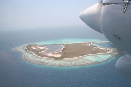
Last week i returned from an 8 weeks vacation in central america (Guatemala, Belize, Honduras, Costa Rica dn Venezuela). During the trip I used my Sony GPS every day, together with three different digital cameras. Just finished the geocoding of all images, over 3500 (ooops). Bellow is one of my favourites, the view from the smal plane leaving Los Roques in Venezuela. Wish i could go back there right now!
Very soon I will get back here to share information about my experiences in different situations / countries. Stay tuned!
FlickrFly made my day
Posted January 6, 2007 by LarsCategories: Flickr, FlickrFly, Geocode, Google Earth
Well, just found a way to put any geocoded image from Flickr into Google Earth (*.KLM) files. There exists a clever script called FlickrFly, so just by adding a simple link next to your picture you get what you want.
Go to my Flickr page, and press the link “fly to this location” (you need Google Earth Installed).
http://www.flickr.com/photos/smocka/347125296/
The script checks the url it was called from (the HTTP_REFERER field), extracts the Photo Id, uses the Flickr API to get details of the photo then constructs a package of KML to feed Google Earth. Thanks a lot for this excellent script, that coould be found at roblog.com
http://www.roblog.com/ukac-ge-docs/
Still lacks a function to export all my pictures at once from Flickr into Google earth…


Recent Comments